Digital Sculpture Project: Laocoon
Laocoon: The Last Enigma
by Rita Volpe and Antonella Parisi
[Translated by Bernard Frischer]
"This is the Hilaocoonte which Pliny mentions..." With these words Giuliano da Sangallo, according to the report of his nephew Francesco, commented on the discovery of the most famous statue group of Laocoon (figure 13), found almost intact and recognized as the same work of art which Pliny the Elder considered one of the most beautiful creations of antiquity. As a child, Francesco had accompanied his famous uncle and Michelangelo to the site in Rome where the Laocoon had been found. The interest and curiosity which the discovery excited over five hundred years ago in Rome were such that the fortunate discoverer was forced to endure an endless flow of visitors to his bedroom, where he had given shelter to the statue in order to better guard it. Scholars and notables lined up to see it, and when it was carried in a festive procession to its final destination in the Belvedere Courtyard of the Vatican a wave of curiosity comparable to that accompanying media events today swept over the general public, which lined the streets of the route. The date of the discovery-January 14, 1506-appears in one of the letters written to recount the event. But the location of the find on the Oppian Hill was given rather vaguely in this and other contemporary letters as "near le Capocce," "near S. Pietro in Vincoli," "not far from the Colosseum," or "near S. Maria Maggiore." Of course, we must take into account the fact that these were almost always letters sent to people not from Rome, so the reference points for the find had to be well-known and easily identifiable. In the suburban landscape of vineyards where the statue was found, such points were few and far between. None of the reports from the period mention the name of the fortunate discoverer and owner of the vineyard, which is, however, recorded in the official document with which in March of 1506 Pope Julius II granted him in exchange for the statue the income from the tolls of the Porta S. Giovanni: Felice de Fredis. His epitaph is known and is now preserved in the Basilica of S. Maria in Ara Coeli (figure 1).
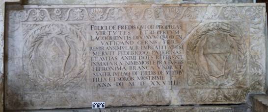
Figure 1. Funerary monument of Felice and Federico de Fredis in S. Maria in Ara Coeli. "Girolama Branca, wife and mother, and Giulia Fredi de' Cavalieri, daughter and sister, set this up in great sorrow to Felice Fredi, who earned immortality both for his own merits and for the discovery of the divine, well-nigh breathing effigy of Laocoon that you behold in the Vatican and to Federico- both carried off by a death all too early- who reproduced the intellectual gifts of his father and grandfather, in the year of the Lord 1529" (translated by T. Lansford, The Latin Inscriptions of Rome. A Walking Guide [The Johns Hopkins Press, Baltimore 2009]). Photograph: Bernard Frischer.
The Evidence of Pliny
But for certain things the collective memory is short, and while the Laocoon quickly became one of the best known sculptural groups in the world, the memory of Felice de Fredis was lost (if not his name), so much so that even today we ask where his vineyard was located and thus where the Laocoon was found. As we will see, this matter is of more than antiquarian interest.
According to most scholars, the group was found where Pliny saw it: in the domus Titi imperatoris. Some maintain that this domus was part of the Domus Aurea (of which a famous pavilion is preserved on the Oppian Hill). Others locate it at other sites on the hill. Some speculate that the statue could have been moved from its original location; others that the Laocoon found in 1506 was an ancient copy of the original seen by Pliny. But two elements can lead to better results. In Bufalini's 1551 Plan of Rome (dating from a time not very long after the discovery), behind the Sette Sale is the indication "Domus Titi," a term which probably indicated the place where the statue was found (see figure 2). A fresco in the Vatican apartments of Pope Julius III (1550-55) gives a panoramic view of the eastern part of the Oppian Hill in which the Laocoon is inserted into the Esquiline landscape and where we can also see the Porta Maggiore, the Porta Tiburtina, the Aurelian Walls, the so-called Temple of Minerva Medica, and the Trophies of Marius (figure 3).
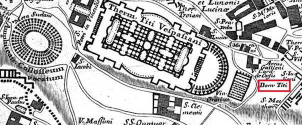
Figure 2. Leonardo di Giovanni Pietro Bufalini, Pianta di Roma (1557). Note red box around the "Dom[us] Titi." Immediately to the left is the no longer extant Vicolo delle Sette Sale; across that street from the "Domus Titi" is the cistern of Trajan's Baths known as the "Sette Sale." Source: "Giuseppe Vasi's Grand Tour of Rome" (http://vasi.uoregon.edu/zoomify_bufalini.html; seen July 15, 2010).
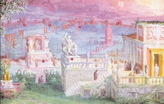
Figure 3. Detail of fresco from the Vatican apartments of Pope Julius III showing: (1) Laocoon; (2) Porta Maggiore; (3) Porta Tiburtina; (4) the Aurelian Walls; (5) so-called Temple of Minerva Medica; and (6) Trophies of Marius. Source: Archeo.
Our research was undertaken on a vast scale in the Secret Archive of the Vatican, in the Archivio Storico Capitolino, in the archive of S. Pietro in Vincoli and in the archive of S. Maria Maggiore, but the most important results were obtained in the Archivio di Stato di Roma. Here are preserved the records of the College of the Capitoline Notaries, which became the focus of our research. The records are found in over 1,900 volumes containing the documents registered by Rome's notaries between 1347 and 1628. The notarial sources represent a precious tool for this kind of investigation. The notary intervened in every act of social life, registering wills, donations, property inventories, dowries and marriages, as well as sales and rental contracts. With a bit of patience and luck it was possible to reconstruct the life of someone who lived five hundred years ago, to piece together his family relationships, to establish his social status, to insert him into a network of relationships and this was the most important thing of all- to identify his real estate properties.
These records had already been consulted by Rodolfo Lanciani and used in his extraordinary work, Storia degli scavi di Roma (4 volumes, Roma: Loescher, 1902-1912). From his immense effort nothing emerged regarding the vineyard of the discoverer of Laocoon, to which Lanciani dedicated two pages of the first volume. But the documents do exist. Why did Lanciani not find them? Our suspicion is that he did not analyze the entire documentation but read only what was signalled by the "rubrics" of the alphabetic catalogues which stand at the head of the volumes, indicating the registered holders of the documents. The rubrics (some contemporaneous and others added later) are an essential guide because they allow the researcher to proceed to a targeted reading of the documents.
A Winning Choice
The first phase of our investigation consisted in perusing the lists of names to find mention of Felice de Fredis. But the results were as disappointing as they had been for Lanciani. In a second phase we used a more analytic approach, leafing through the volumes page by page and ignoring the indications of the rubrics, which sometimes appeared to be misleading. This method turned out to be successful. We discovered two documents of fundamental importance. Both were written in a complex hand and both were unpublished.
Figure 4. Contract for the purchase of a vineyard near S. Pietro in Vincoli bought by Felice de Fredis from the Sisters of St. Catherine of Siena on November 14, 1504. The document is preserved in the Archivio di Stato, Rome in the deposit of the Collegio dei notai capitolini. Source: Archeo.
Vineam quinque petiarum plus vel minus quante sint cum vasca vascali tino et statio liberis et cum quodam petio canneti in ea existenti que vinea sita est intra menia vel in loco qui dicitur Sancto Pietro ad Vincula inter hos fines cui ab uno latere tenet vinea de messer de Gualdaronibus ab alio latere tenet vinea (...) ab alio latere est viculus vicinalis.
The vineyard thus had a total size about 1.5 hectares and was equipped to produce wine. De Fredis paid immediately and in cash the requested sum of 135 ducats--not much if compared to the advantages that he was to obtain from the purchase. The document is historically important but does not resolve the matter of the exact location of the vineyard. The toponym is generic and the data relative to the bordering properties are incomplete. Cited are the property of a certain "Messer de Gualdoaronibus" and a local road.
The Domus of the Discovery?
The second document turned out to be more useful. It is a contract written on March 2, 1527. Felice de Fredis has been by now dead for eight years. The vineyard has been rented by his widow Girolama in the name of her son Federico, who is still a minor, to the abbot of the church of S. Sebastiano furoi le Mura. The property is thus described:
Prostitutes, Innkeepers, and Notaries
This ensemble of data provided new impetus to our investigation, which proceeded with the identification of all the documents relating to the properties bordering the vineyard of de Fredis. From our research has emerged a living cross-section of sixteenth-century Rome. Here interacted, in perfect harmony, prostitutes of high rank such as Lucrezia de Clarice, known also in the trade as "Matrema non vole" ("Mamma does not want to"), successful innkeepers such as Marco dello Cavalletto, owner of a taberna vinaria in the rione Ponte, and highly respectable notaries such as Teodoro de' Gualderoni. On the basis of cross-referenced comparisons, adding piece to piece, we were able to solve the puzzle of how all the properties in the area fit together. For our base map, we used the plan of Giovanni Battista Nolli (Nuova Pianta di Roma, Rome 1748) because it was created with a azimuthal projection and thus can be superimposed over a modern map (figure 5).
The result of the work was surprising: the vineyard of Felice de Fredis rose to the east of the cistern between the ancient Vicolo delle Sette Sale which bordered it and the modern Via Merulana. All the hypotheses which placed it in the area of the Baths of Trajan and of the Domus Aurea have thus been refuted thanks to the precious and impartial contribution made by the maps and the documents.
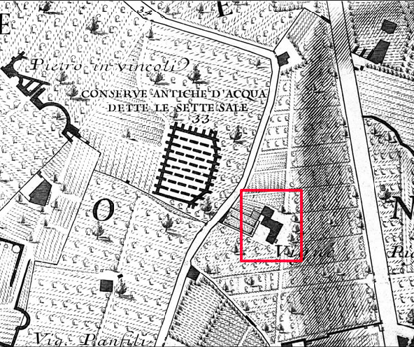
Figure 5. Giovanni Battista Nolli, Nuova Pianta di Roma (Rome, 1748). Detail showing the cistern known as the "Sette Sale" (nr. 33), the Vicolo delle Sette Sale (to the immediate right), and across the street, in the red box, the building in the vineyard once owned by Felice de Fredis. Source: "The Interactive Nolli Map Website" (http://nolli.uoregon.edu/; seen July 15, 2010).
In the modern topography of Rome we find ourselves in the area immediately behind the Sette Sale, toward the east, in a quarter now completely urbanized and profoundly different from the panorama of vineyards preserved until the end of the nineteenth century. Incredibly, however, besides the unmistakable profile of the Sette Sale, in the modern urban fabric there survives one other vestige: inside the area is perfectly visible and well preserved the structure present on Nolli's plan with the characteristic form of a "L." The hypothesis that this is the domus built by de Fredis and attested in the document of 1527 is cogent (figures 6 and 7).
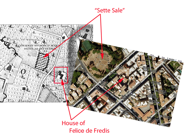
Figure 6. Nolli plan (left) and corresponding area in Rome today from Google Maps (right). Source of the Nolli Plan: The "Interactive Nolli Plan Website" (http://nolli.uoregon.edu/; seen July 15, 2010).
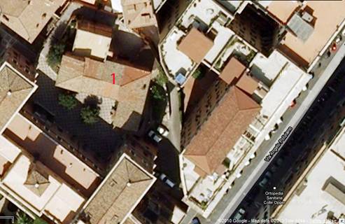
Figure 7. Close-up aerial view of the De Fredis house (nr. 1) on the modern property of the Sisters of St. Joseph of Cluny. Source: Google Maps.
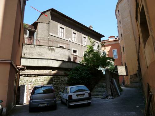
Figure 8. De Fredis house (red arrow) today. Note how it sits ca. 3 meters above the modern level of surrounding buildings. Photograph: Bernard Frischer.
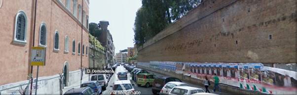
Figure 9. Via Mecenate viewed looking south. Source: Google Maps.
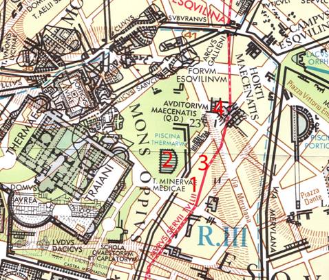
Figure 10. Map showing archaeological features of the zone, including the Servian Wall ("Murus Servii Tullii'), "Sette Sale" (2), the tract of the Servian Wall preserved at Via Mecenate 35 (3), and the Auditorium of Maecenas (4). The house of Felice de Fredis is nr. 1 on the plan. Source: I. Grande, Roma Urbs imperatorum aetate (Rome 2005).
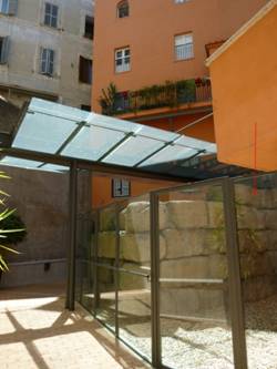
Figure 11. Tract of Servian Wall (red arrow) found inside courtyard at Via Mecenate 35 (3 on the map in figure 10). Photograph: Bernard Frischer.
The Gardens of Maecenas
But ridges like this one, precisely because of their height, were used not only for the erection of defensive walls but often also for the passage of aqueducts, which ran at high quota levels. That a branch of the aqueduct passed through this area is certain, at least in the Trajanic period, when it had to furnish several million liters of water to the cistern of the Sette Sale (cf. nr. 2 on the map in figure 10). Among the aqueducts that supplied the Esquiline the only one that could run at this level, higher than 50 meters above sea level, was the Aqua Iulia. Built by Agrippa during or slightly after his aedileship in 33 B.C., the aqueduct brought a general renewal of the entire water system of Rome. In the same years, Maecenas created his horti. Even though their exact extent cannot be defined (cf. the map in figure 10), the area immediately around the spot where de Fredis was to build his house certainly belonged to Maecenas' Gardens. When the horti were laid out, the old city walls were completely deprived of their original purpose. We can speculate that the embankment behind the walls could have carried a branch of the new aqueduct, which, before continuing toward the valley, watered the new gardens. Maecenas and Agrippa were both close collaborators and friends of Augustus.
When he died in 8 B.C., Maecenas left his property to Augustus. The luxury and wealth of this estate made it a suitable imperial residence similar to the highly praised Campanian villas. This can be seen from the fact that when in 2 A.D. Tiberius returned to Rome from his self-imposed exile on Rhodes, he took up residence here. The suggestion is strong that the Rhodian artists who sculpted both the statues of Sperlonga (at the villa attributed to Tiberius) and the Laocoon could in some way have been in the service of Tiberius, who lived for a long time on Rhodes. The Laocoon would thus have been created for Tiberius for the horti in which he lived.
Always in the Same Spot
In contrast, if one accepts the dating of Laocoon to sometime in the period 40 to 20 B.C., the group would have been part of a design developed by Maecenas himself in the years in which his gardens were being laid out. In either case, then, the Laocoon would never have been moved from its original location. The domus of the princeps Titus (mentioned by Pliny but otherwise not known) could have been the very same residence in the horti of Maecenas, which was without doubt worthy of a princeps and where Tiberius had also once lived.
The archaeological map of the zone has no remains in the area that we have attributed to the vineyard of de Fredis. Remains not too far away present the same orientation as de Fredis' house. This makes it possible that the foundations of his building made use of ancient structures. And it is thus probable that the Laocoon group was situated in a building backing up to the old city wall (like the Auditorium of Maecenas; figure 12) and provided with water. The Laocoon will have been part of a complex decorative program, similar to the one at Sperlonga, perhaps standing with other sculpture linked to the story of Troy. It probably had a special setting in a scenographic composition that made its relocation extremely difficult.
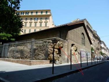
Figure 12. Auditorium of Maecenas. Red arrows indicate remains of the Servian Wall, to which the Auditorium was adossed. Photography: Bernard Frischer.
If we next examine the circumstances in which the Laocoon was discovered- practically intact but with various lacunae (figure 13)- the best explanation is abandonment in late antiquity or the early middle ages and later collapse of the rooms causing some damage and the opportunity of spoliation. Moreover, this is not the only statue found practically intact in the rich depths of the Esquiline. Into this context Ludwig Pollak's find in 1905 of the missing arm (figure 13) fits quite well. He saw it in the shop of a Roman stonecutter on the nearby Via Labicana and identified it as that of Laocoon (or better, according to him, of a copy), reporting that the arm came from the neighboring area. In the years immediately prior to this, around 1903, works were undertaken precisely on the enclosure wall and on the property of the Sisters of St. Joseph of Cluny, which could have brought the find to light.
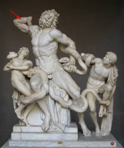
Figure 13. Statue of the Laocoon, Vatican Museums. Red arrow points to the right arm found by L. Pollak in 1905 and restored to the statue by F. Magi in the 1950s. Photograph: Bernard Frischer.
Documentation and the Territory
After two years of work, we conclude by noting that these results would not have been possible without a deep and positive collaboration between scholars of different disciplines. The find of the individual document- whatever its importance- would have remained a goal in itself if it had not been placed into the territorial context to which it belonged. All the archival data minutely collected have been related to each other and have found clarification and confirmation only in the moment in which they were transferred and placed onto the territory, reconstructing the ancient panorama and its vicissitudes. The territory itself, in this case part of a city, has preserved stratified signs of these events: this confirms yet again that the study of the ancient city cannot disregard an analysis of the later phases of the city's history. Only a reconstruction of Rome of the sixteenth century (mapped on the eighteenth-century plan of Nolli) has been able to throw light onto the Rome of the Augustan age[1].
[1]This article originally appeared under the title, "Laocoonte. L'ultimo engima," in Archeo 299, January 2010, pp. 26-39. The translator expresses his thanks to the publisher and authors for permission to translate it, to use the illustrations in figures 3 and 4, and to publish it on this website. He also thanks Paolo Liverani for bringing the article to his attention and for helping him to obtain the necessary permissions; Jane Crawford for her eagle proofreader's eye; and Sister Paola for permission to enter the property of the Sisters of St. Joseph of Cluny and to photograph the building attributed to Felice de Fredis.
Copyright © 2009-23. Last updated: September 12, 2023.
Webpage sponsored by the Virtual World Heritage Laboratory.